Extreme Low Water Ops

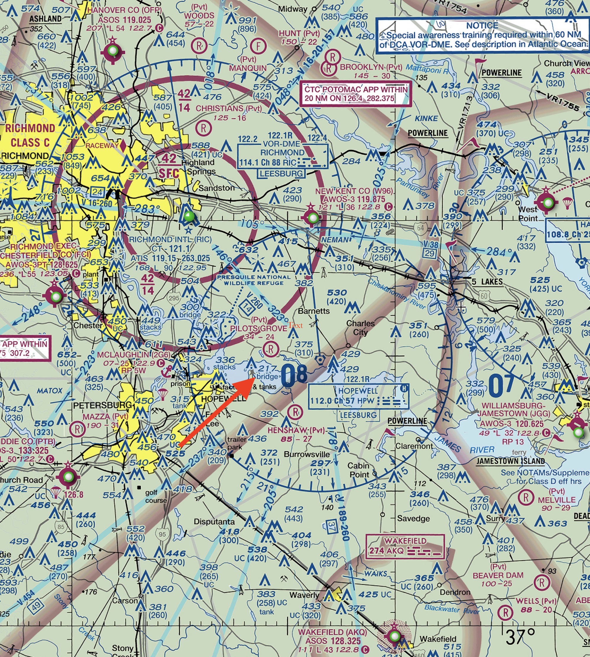
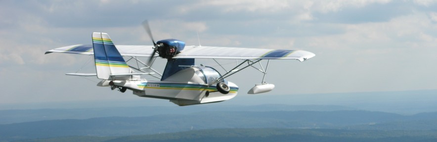
At Low Tide: think of the bay as an airport, with runways and taxiways–and other areas to keep clear of.

Most of the time the water is deep enough everywhere in the river for takeoffs, landings, and fooling around. A few times a year, however, the moon, sun, rain, and wind all turn unfavorable together to make the center of our bay “dry.” At those times, boats and seaplanes need to stay out of the middle of the bay until the tide comes back in.

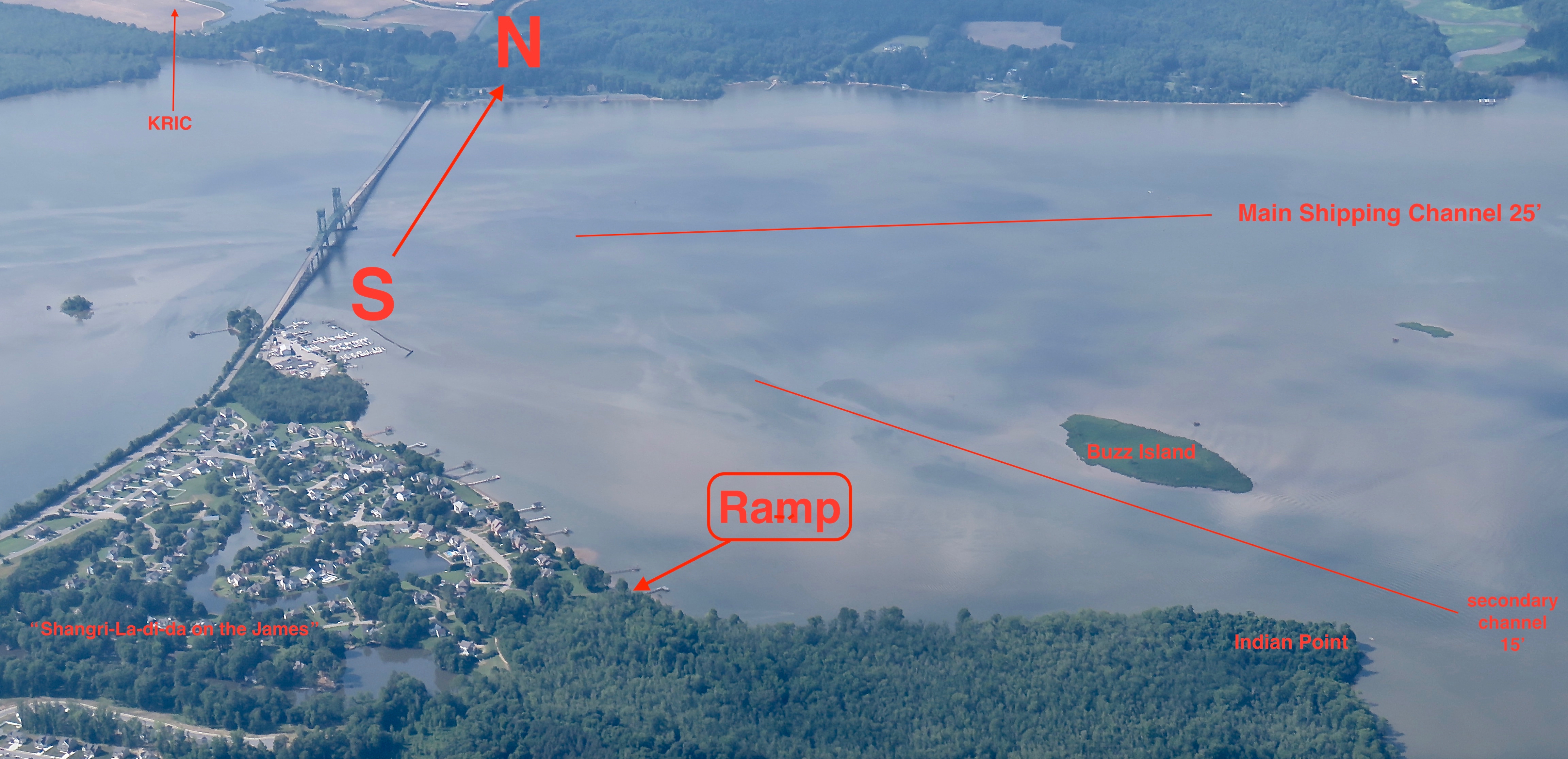
Fortunately, the water around the edges is always deep enough for most amphibs and floatplanes, even during those rare extremely low tides. Here’s a false-color photo to show where those low-tide channels are. The channels are like runways on an airport.

(Don’t let this image scare you, by the way. This was at an extremely low tide. The bay never really looks like this. And anyway, we never schedule spash-ins for low tide.)

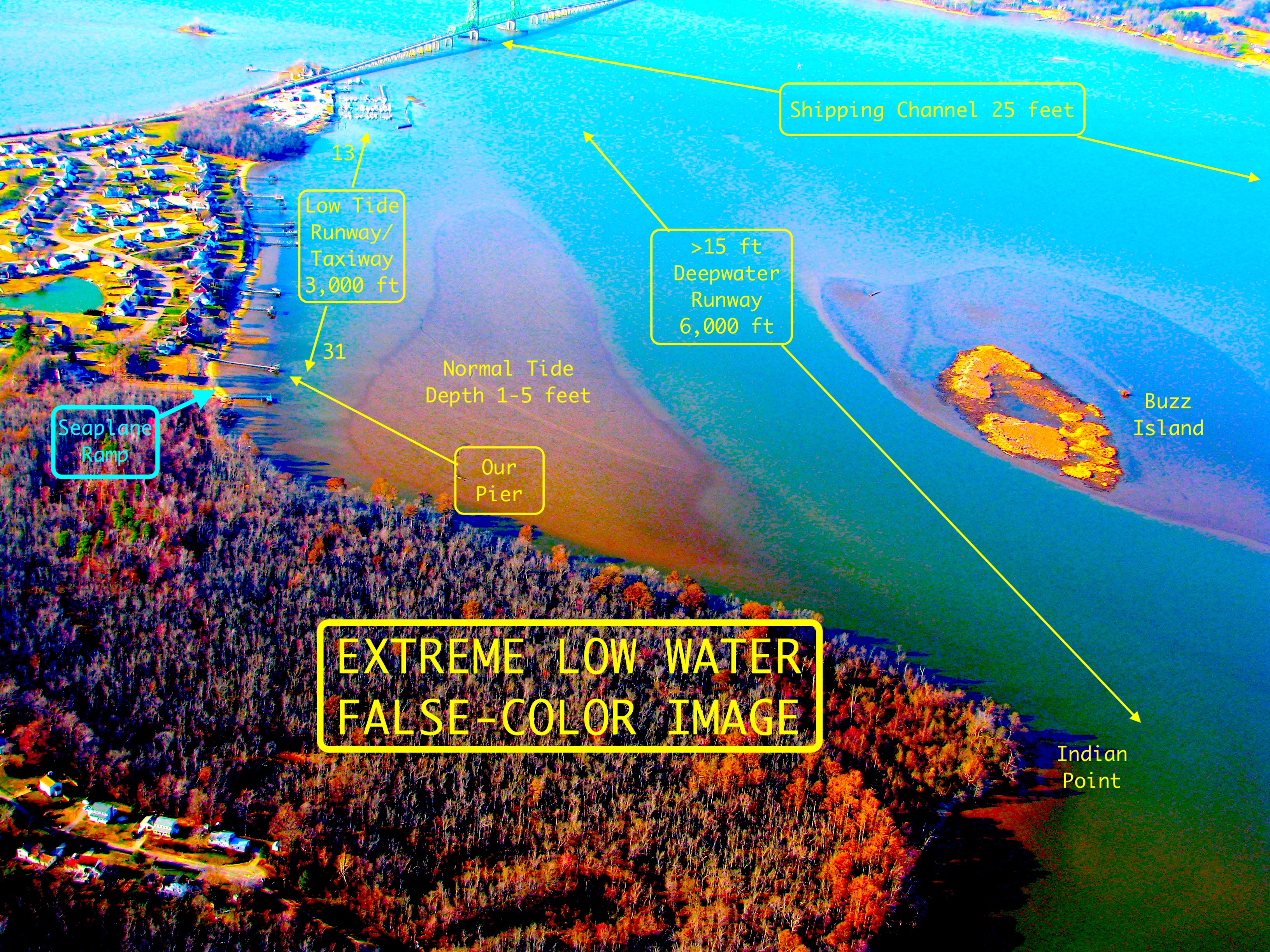
Brown is soft mud. Blue-green is water. The shallowest I’ve ever seen it in the small channel on the left was 3 feet, off the end of our pier. That was on a cold winter evening with a strong NW wind blowing the river downstream. The small channel was about 3.5 feet deep at our pier when I took this photo.

At low and medium tide I often land in the deep channel beside Buzz Island, between Indian Point and the Bridge. If the wind is wrong for that runway, I land near the bridge–any direction is fine there. Then I taxi to the marina and turn south.

Sometimes at low tide I land in the small channel near the piers, and I often take off there, particularly when the wind is from the north.

The important thing is to stay out of the brown area when the water is shallow there–less than one foot deep. The river bottom is soft mud. (Too soft to walk on; you might have to lie down and swarm over it.) With enough engine power you can skid along on it and take off. But even if you should get stuck, the tide will float you in an hour or so, with no harm done.

HOW DEEP IS THE WATER in that “brown” area?

Here’s how to find out:

METHOD 1: Before taking off, check a tide table for Jordan Point: https://tidesandcurrents.noaa.gov/noaatidepredictions.html?id=8638476 By coincidence, the water depth in the shallowest part of our bay is close to the tide tables’ prediction. It’s deeper around the edges of the bay.

NOTE that the tide tables are predictions; but wind and other factors can affect them +/- about 50%. So if a tide table says the tide height is “2.0 feet” the actual depth is likely between 1 and 3 feet.

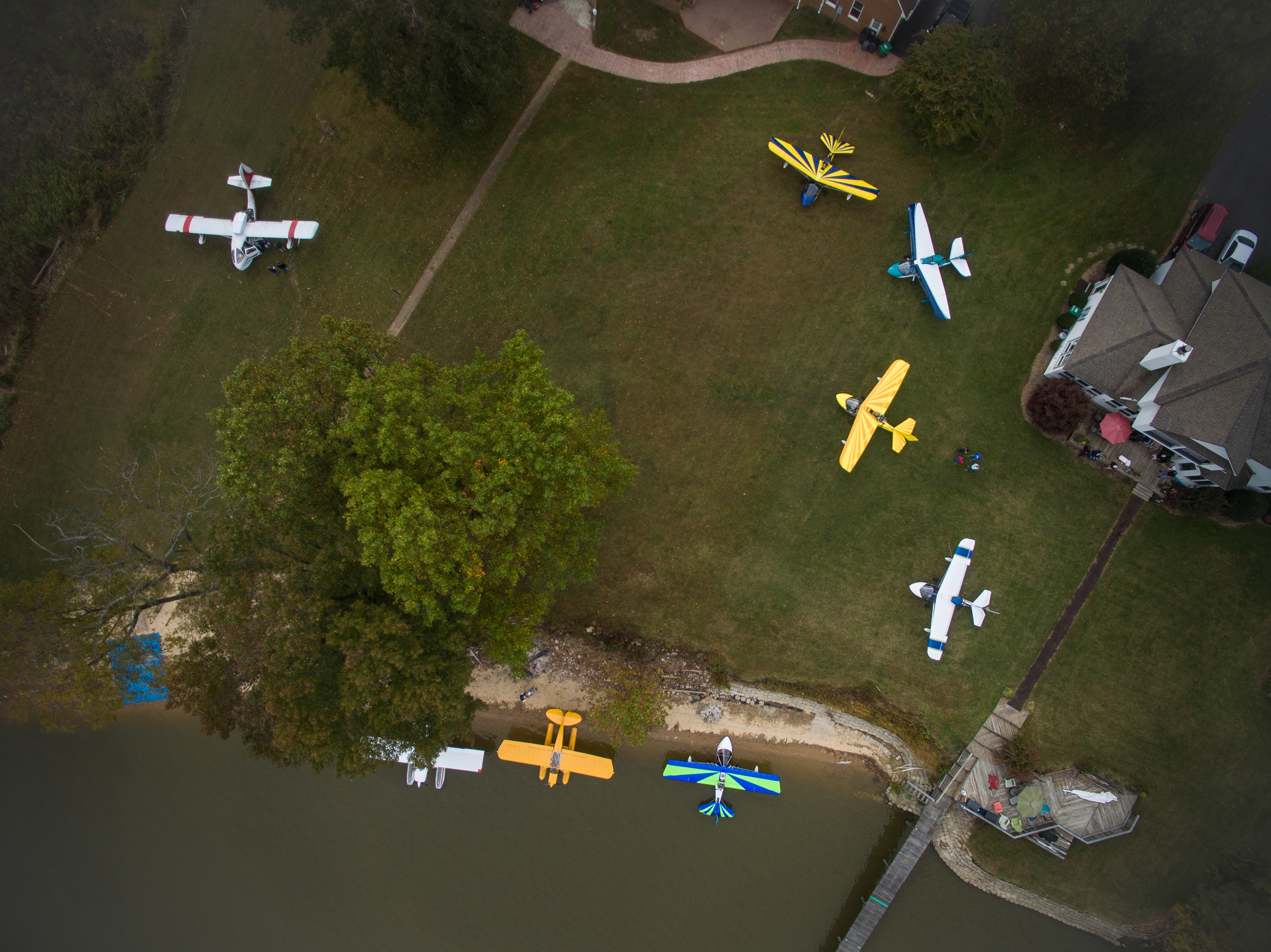
METHOD 2: Fly over our pier and look for the painted stripes. Note where the edge of the water is in relation to them. (It was about 2.5 feet deep in the middle of the bay when I took the picture below.)

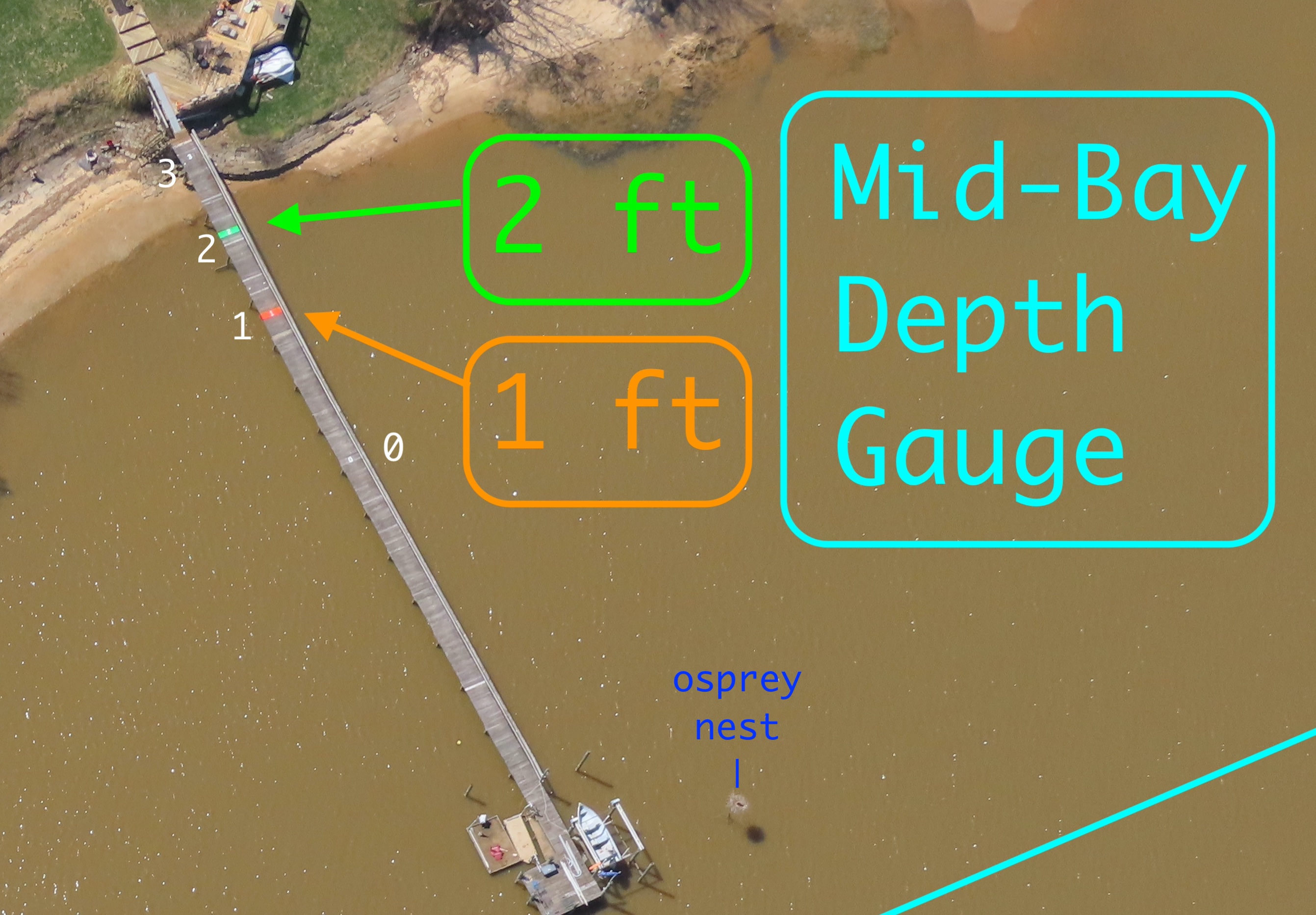
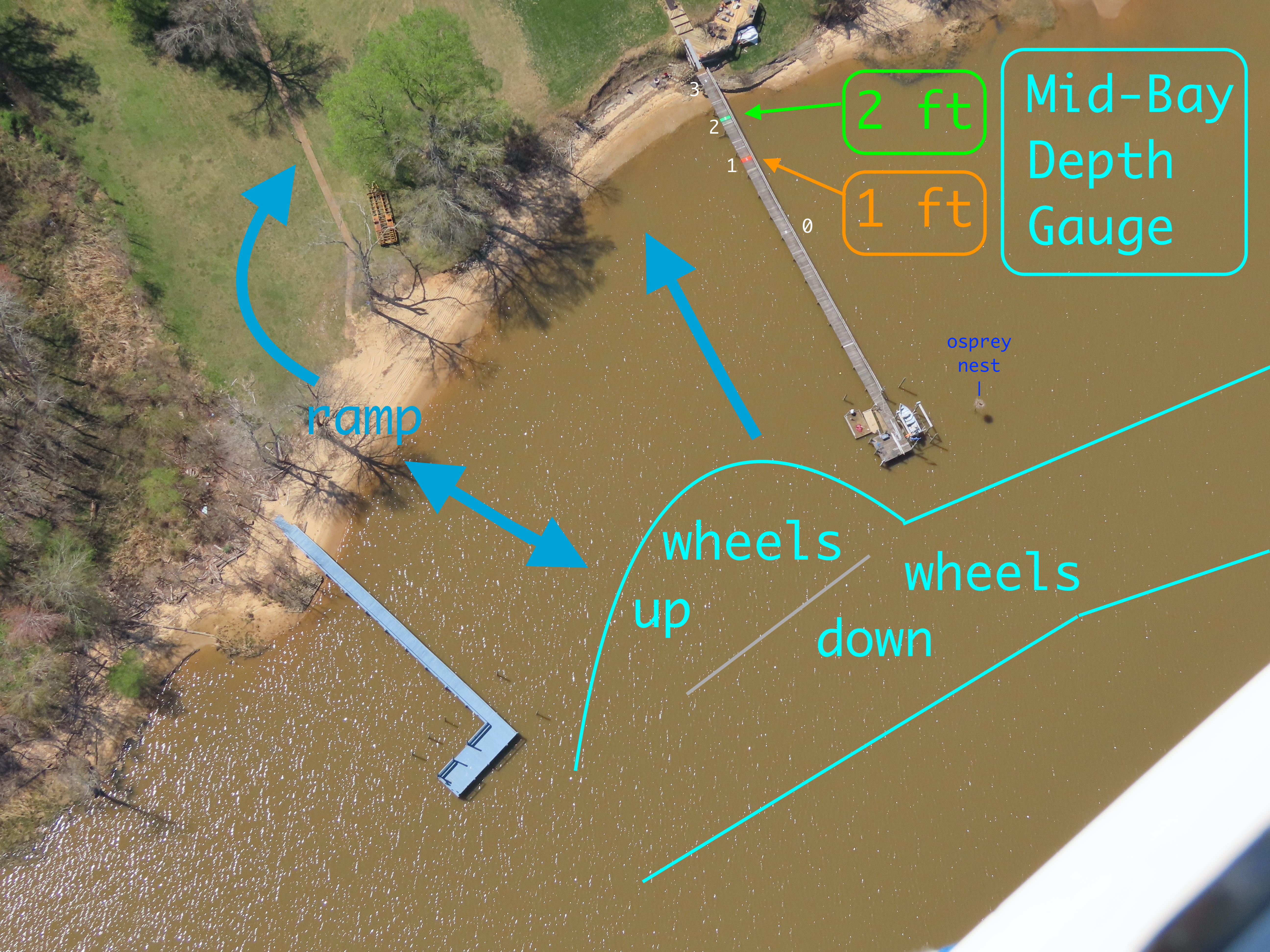
Here’s the full photo, with guides for arriving and departing.

My SeaRey draws about 1.5 feet in displacement mode with the wheels up, so when the water’s edge is at the 2 ft stripe, I can go anywhere in the bay.

On the step I’m fine at the 1 ft stripe.

I lower or raise the gear at the end of our pier, while in the small channel.

(You don’t see the blue tarp seaplane ramp because we put it out only for splash-ins. But it’s just an aiming point. If the beach is clear you can get onto the grass without the tarp.)

If your seaplane is larger than a Seabee or a Lake amphibian, just land in the deep Buzz Island channel or the shipping channel and anchor off-center in the Buzz Island channel. We’ll pick you up in a powerboat.

2022 Splash-In

AHOY !!!

We’re having a SPLASH-IN

Saturday, July 23, 2022

and we hope you can come!


X” marks the spot

TajMahouse-clouds 
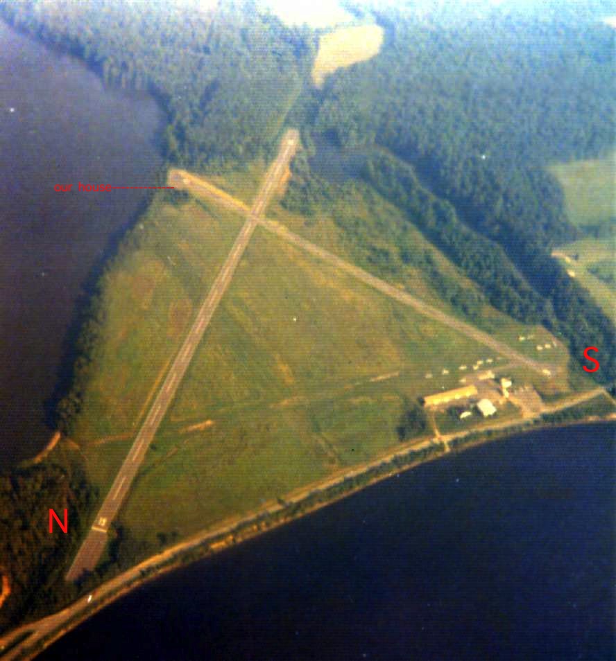
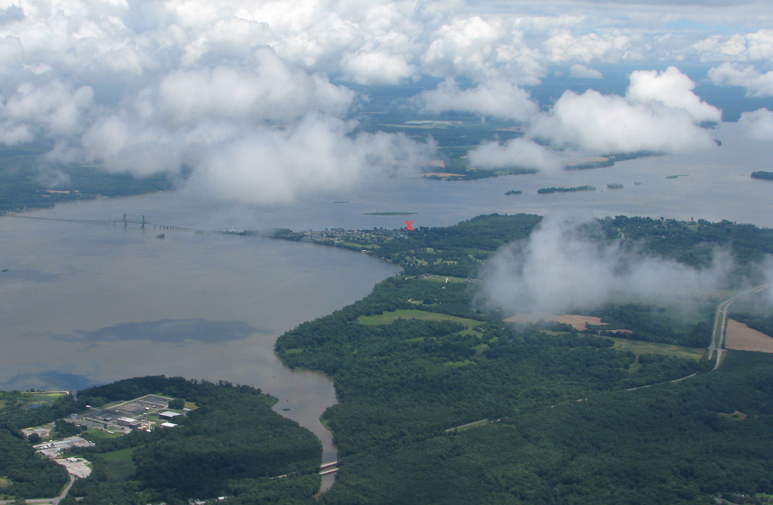
(view is to the northeast, toward the HPW VOR)

Lunch around noon. Nothing fancy, but plenty of grub: BBQ, grilled burgers, hotdogs, etc.

LOCATION

The Taj Mahouse, in Shangri-La-di-da, on the James River, near Hopewell VA. We’re on the east side of Jordan Point, just SE of the Route 106/156 Benjamin Harrison drawbridge. (Google the coordinates below or “tar bay va”)

Taj-Sectional-Lg.jpg

Coordinates

N 37.305°          W -77.215°
N 37° 18.2909'     W -77° 12.8966'
N 37° 18' 17.45"   W -77° 12' 53.79"

5 miles from HPW on the 260° radial


Radio frequency:
  123.45 (“fingers”)

Phone & Text:    804-543-7110
Email:          DonMaxwell@AbstractConcreteWorks.com
Street address:   10463 Jordan Parkway, North Prince George, VA 23860.

Fresh water, but 3 foot tide. High tide on July 23, 2022 is at 12:12 PM.  Sunset will be at 8:24 PM, and low tides are at 6:44 AM and 6:28 PM.  Taxiing up onto the lawn should be no problem after 9:30. I’ll email a WX estimate the evening before. (Please be sure we have your email address.)

TajMahouse-splash-In

ARRIVING

Look for the orange windsock on our pier and call “Taj Mahouse” or “Maxwell” on 123.45. Or just land.

SeaReys, Aventuras, ICONs, Seabees, and other amphibs can taxi across the sandy beach on the blue tarp and onto Neal’s lawn next door, with plenty of room to park. Use LOTS of power on the sand and don’t stop until you’re well onto the grass.  Then turn right.

Video of taxiing onto the grass:  https://www.youtube.com/watch?v=1GQoWLWkVrg

Aim for the blue tarp on the beach.

Floatplanes with small tires can probably get across the beach okay.  Several have done it with ease. Or you can tail in to the beach or anchor.  (There’s only 1 buoy, so bring an anchor if you’ll need one.)  If you anchor, we’ll pick you up with the Large Marge Party Barge & Self-Propelled Seaplane Tender.  You’re welcome to try for the grass, though. If you happen to get stuck in the dry sand, there will be mats and plenty of muscle to get you free.

DEEP WATER ANCHORAGE: PBYs, Clippers, and other seaplanes that draw more than 3 feet of water should anchor in the 15+ foot deep channel that runs just west of Buzz Island, the flat island 2,000 feet offshore.  That channel runs between the bridge and Indian Point, to the east of us.  As a deepwater runway it’s 12/30 (approx.), about 6000 ft long.  Anchor out of the center of the channel. We’ll pick you up with a motorboat.

EXTREME LOW TIDE INFO:  We can always get the seaplane in and out here–but once in a great while there’s an unusually low tide, and it’s good to know how to navigate then, just in case. Here’s how:  https://amphibflyer.com/2022/03/28/extreme-low-water-ops/

(Here’s an older version with similar info http://abstractconcreteworks.com/TajMahouseSeaplaneOps/TajMahouseSeaplaneOps.html )

If the wind is from the east, please consider approaching over the trees between the marina and the houses instead of low over the houses. If the water is glassy, one good approach is to use the small, flat island (Buzz Island) in the middle of the bay as your LVR. Here’s a quick video: https://www.youtube.com/watch?v=96n2kH3tqwA&feature=youtu.be

FUEL:  Sorry, no AvGas. But there’s a high-volume Exxon station just a mile down the road with 93 octane and also 89 octane alcohol-free gas.  We’ll have several gas cans and a car at the ready.  The marina on the point has 89 alcohol-free gas, too.

Fun and Games? If anyone’s interested we might try grapefruit bombing or short takeoff, but only if it’s going to be fun for everyone. (Please let us know your feelings about that stuff.)

We’re looking forward to seeing you on the 23rd of July!  If you need to RON, no prob.

= Don & Carol Maxwell

P.S.  Please let us know (for the food count) if you’re coming.

P.P.S. Please pass this on to other seaplane pilots who might be interested in coming.

Rain Date:  Sunday, July 24. 

 ___________________

Here’s Kevin’s drone view of the splash-in site:

SplashIn2015-103-Overhead

The blue rectangle, lower left, is the ramp to taxi up onto the lawns.  Our house is on the right, the white one.

___________________

VIDEOS OF A FEW RECENT SPLASH-INS

2021:  https://youtu.be/ux2u6nFK4s4

2019:  https://www.youtube.com/watch?v=F4LnwzAd_-I

2018:  https://www.youtube.com/watch?v=Hi0dlrF2ZUM

2017:  https://www.youtube.com/watch?v=ejqEGCZLLDw

2016:  https://www.youtube.com/watch?v=aHWmePKMVj8

__________________

================

USEFUL WEATHER FORECASTS

Intended for hang gliders; excellent for seaplanes:  http://www.usairnet.com/cgi-bin/launch/code.cgi?state=VA&sta=KRIC 

Balloonists’ Wind Forecast:  http://ryancarlton.com/wind.php?loc=KFCI&units=KTs&tempformat=0&altformat=0

And now there’s Windy.com and the “Windy” iPhone app.  Its forecasts for hurricane Florence were much more accurate than the other sources I checked, including 1-800-WX-BRIEF and the AOPA’s site.  The “Windy” link above should open in a new window, showing wind (colors and moving arrows), isobars, airports (colored circles), and with luck a flag showing our location. Let your mouse hover over things for popup info. And try the many menus.

My new fav is the MyRadar app, which can combine radar, prog chart, AIRMETS. flight plans, and (for a fee) sectional charts.

___________________

General info for other days:  It’s always possible to get onto the beach here. But if the tide is exceptionally low, you might want to tie up to the buoy or anchor, and we’ll pick you up with the Large Marge Party Barge & Self-Propelled Seaplane Tender. Just phone or text first to be sure we’ll be home: 804-543-7110.

Video of arriving and taxiing onto the beach at an unusually low tide: https://youtu.be/GnOK9cfh2go

Sunday high tides are roughly 50 minutes later than Saturday’s, and the tide height re-occurs very roughly every 14 days.

Useful Tide Tables for Jordan Point, where we live on the James River

Browser (simple and efficient; works in a phone browser, too): https://tidesandcurrents.noaa.gov/noaatidepredictions.html?id=8638476

http://www.tides4fishing.com/us/virginia/jordan-point

Note:  The tide tables are good for times, but water depth is about 50% dependent on wind.

VERY RARELY–a few times a year, usually in winter–the tide gets extremely low and the muddy river bottom is exposed in the middle of our bay. It’s still easy to land and take off around the edges, though. Here’s how: https://amphibflyer.com/2022/03/28/extreme-low-water-ops/

___________________

Jordan Point in 1973:

Airport-Hopewell_VA_73Sep8_se

Alas, it’s a subdivision now. We live right on the numbers of runway 26. More about that airport:  http://www.airfields-freeman.com/VA/Airfields_VA_Richmond_S.htm#hopewell

___________________