AHOY !!!
We’re having a SPLASH-IN
Saturday, September 14, 2024
and we hope you can come!
“X” marks the spot
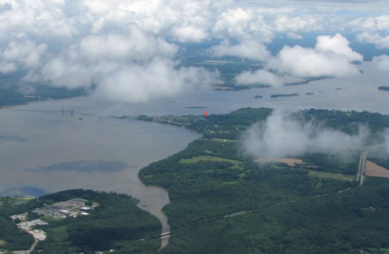 (view is to the northeast, toward the HPW VOR)
Lunch around noon. Nothing fancy, but plenty of grub: BBQ, grilled burgers, hotdogs, etc.
LOCATION
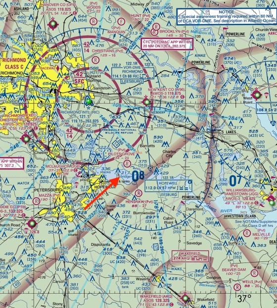
The Taj Mahouse, in Shangri-La-di-da, on the James River, near Hopewell VA. We’re on the east side of Jordan Point, just SE of the Route 106/156 Benjamin Harrison drawbridge. (Google the coordinates below or “tar bay va”)
Coordinates

N 37.305°          W -77.215°
N 37° 18.2909'     W -77° 12.8966'
N 37° 18' 17.45"   W -77° 12' 53.79"

5 miles from HPW on the 260° radial
Radio frequency: 123.45 (“fingers”)
Phone & Text: 804-543-7110
Email: DonMaxwell@AbstractConcreteWorks.com
Street address: 10463 Jordan Parkway, North Prince George, VA 23860.
Fresh water, but 3 foot tide. High tide on September 14 2024 is at 12:28 PM. Sunset will be at 7:17 PM, and low tides are at 7:00 AM and 6:59 PM. Taxiing up onto the lawn should be no problem after 9:30. I’ll email a WX estimate the evening before. (Please be sure we have your email address.)
ARRIVING
Look for the orange windsock on our pier and call “Taj Mahouse” or “Maxwell” on 123.45. Or just land.
SeaReys, Aventuras, ICONs, Seabees, and other amphibs can taxi across the sandy beach on the blue tarp and onto Neal’s lawn next door, with plenty of room to park. Use LOTS of power on the sand and don’t stop until you’re well onto the grass. Then turn right.
Video of taxiing onto the grass: https://www.youtube.com/watch?v=1GQoWLWkVrg
Aim for the blue tarp on the beach.
Floatplanes with small tires can probably get across the beach okay. Several have done it with ease. Or you can tail in to the beach or anchor. (There’s only 1 buoy, so bring an anchor if you’ll need one.) If you anchor, we’ll pick you up with the Large Marge Party Barge & Self-Propelled Seaplane Tender. You’re welcome to try for the grass, though. If you happen to get stuck in the dry sand, there will be mats and plenty of muscle to get you free.
DEEP WATER ANCHORAGE: PBYs, Clippers, and other seaplanes that draw more than 3 feet of water should anchor in the 15+ foot deep channel that runs just west of Buzz Island, the flat island 2,000 feet offshore. That channel runs between the bridge and Indian Point, to the east of us. As a deepwater runway it’s 12/30 (approx.), about 6000 ft long. Anchor out of the center of the channel. We’ll pick you up with a motorboat.
EXTREME LOW TIDE INFO: We can always get the seaplane in and out here–but once in a great while there’s an unusually low tide, and it’s good to know how to navigate then, just in case. Here’s how: https://amphibflyer.com/2022/03/28/extreme-low-water-ops/
(Here’s an older version with similar info: http://abstractconcreteworks.com/TajMahouseSeaplaneOps/TajMahouseSeaplaneOps.html )
If the wind is from the east, please consider approaching over the trees between the marina and the houses instead of low over the houses. If the water is glassy, one good approach is to use the small, flat island (Buzz Island) in the middle of the bay as your LVR. Here’s a quick video: https://www.youtube.com/watch?v=96n2kH3tqwA&feature=youtu.be
FUEL: Sorry, no AvGas. But there’s a high-volume Exxon station just a mile down the road with 93 octane and also 89 octane alcohol-free gas. We’ll have several gas cans and a car at the ready. The marina on the point has 89 alcohol-free gas, too.
Fun and Games? If anyone’s interested we might try grapefruit bombing or short takeoff, but only if it’s going to be fun for everyone. (Please let us know your feelings about that stuff.)
We’re looking forward to seeing you on the 14th of September 2024! If you need to RON, no prob.
= Don & Carol Maxwell
P.S. Please let us know (for the food count) if you’re coming.
P.P.S. Please pass this on to other seaplane pilots who might be interested in coming.
Rain Dates: Sunday, 15 September 2024 and Saturday 28 September 2024.
___________________
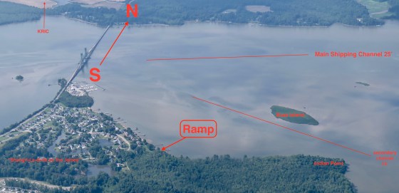
Here’s Kevin’s drone view of the splash-in site:
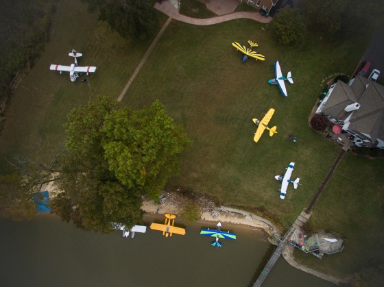
The blue rectangle, lower left, is the ramp to taxi up onto the lawns. Our house is on the right, the white one.
___________________
VIDEOS OF A FEW RECENT SPLASH-INS
2021: https://youtu.be/ux2u6nFK4s4
2019: https://www.youtube.com/watch?v=F4LnwzAd_-I
2018: https://www.youtube.com/watch?v=Hi0dlrF2ZUM
2017: https://www.youtube.com/watch?v=ejqEGCZLLDw
2016: https://www.youtube.com/watch?v=aHWmePKMVj8
__________________
================
USEFUL WEATHER FORECASTS
Intended for hang gliders; excellent for seaplanes: http://www.usairnet.com/cgi-bin/launch/code.cgi?state=VA&sta=KRIC
Balloonists’ Wind Forecast: http://ryancarlton.com/wind.php?loc=KFCI&units=KTs&tempformat=0&altformat=0
And now there’s Windy.com and the “Windy” iPhone app. Its forecasts for hurricane Florence were much more accurate than the other sources I checked, including 1-800-WX-BRIEF and the AOPA’s site. The “Windy” link above should open in a new window, showing wind (colors and moving arrows), isobars, airports (colored circles), and with luck a flag showing our location. Let your mouse hover over things for popup info. And try the many menus.
My new fav is the MyRadar app, which can combine radar, prog chart, AIRMETS. flight plans, and (for a fee) sectional charts.
___________________
General info for other days: It’s always possible to get onto the beach here. But if the tide is exceptionally low, you might want to tie up to the buoy or anchor, and we’ll pick you up with the Large Marge Party Barge & Self-Propelled Seaplane Tender. Just phone or text first to be sure we’ll be home: 804-543-7110.
Video of arriving and taxiing onto the beach at an unusually low tide: https://youtu.be/GnOK9cfh2go
Sunday high tides are roughly 50 minutes later than Saturday’s, and the tide height re-occurs very roughly every 14 days.
Useful Tide Tables for Jordan Point, where we live on the James River
Browser (simple and efficient; works in a phone browser, too): https://tidesandcurrents.noaa.gov/noaatidepredictions.html?id=8638476
http://www.tides4fishing.com/us/virginia/jordan-point
Note: The tide tables are good for times, but water depth is about 50% dependent on wind.
VERY RARELY–a few times a year, usually in winter–the tide gets extremely low and the muddy river bottom is exposed in the middle of our bay. It’s still easy to land and take off around the edges, though. Here’s how: https://amphibflyer.com/2022/03/28/extreme-low-water-ops/
___________________
Jordan Point in 1973:
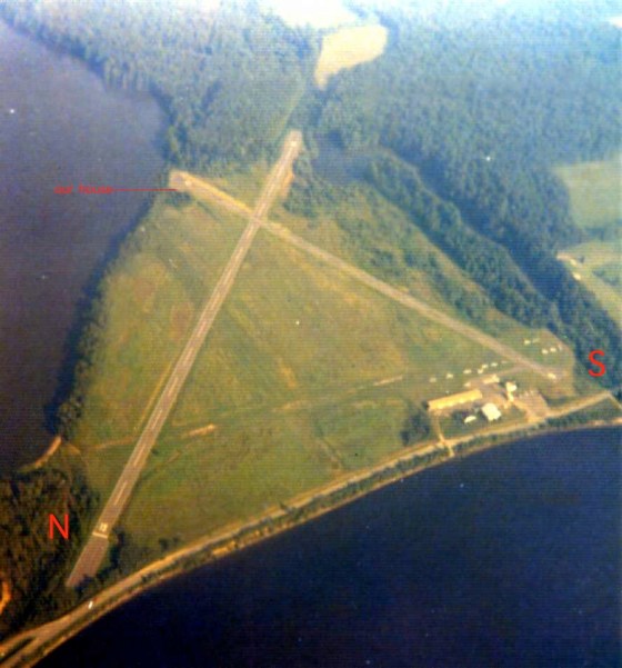
Alas, it’s a subdivision now. We live right on the numbers of runway 26. More about that airport: http://www.airfields-freeman.com/VA/Airfields_VA_Richmond_S.htm#hopewell
___________________
